| |
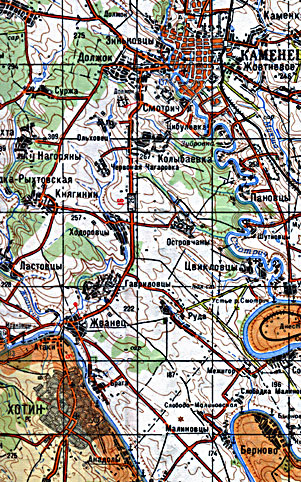
This is a small part of the 1:200,000
topographic map of Kmel'nitskaya Oblast', Ukraine. The Smotrich river flows
from the north. At Kam'yanets it enters an ox-bow, triple bend, turning sharply
east, then north, then east, then south, then west, then north, then west, then
south again to follow a very winding route on to the Dnister River downstream
from Khotin. The old city occupies the oval with major axis north-south in the
middle of this ox-bow. The modern city surrounds this area on all sides. The
Dnister likewise is quite sinuous with two ox-bows between Khotin and the
confluence of the Smotrich. The elevation of the Dnister at Khotin is about 110
meters. The elevation of the Smotrich at Kam'yanets is about 137 meters.
Kam'yanets castle is 1. and Khotin fortress is 2 on this map.
|
|