{short description of image}

CHUFUT - KALE

TRANSLATE THIS PAGE


George Page
Misha Jelisavcic
John Sloan

We were most fortunate that Pavel Lyashuk was able to arrange for Dr Oleg Belli to take the time to go with us and act as guide throughout our visit in summer of 1997. Dr. Belli is a well-known expert on all the cave cities of southern Crimea and has made a special study of the history of the Kariates in connection with their occupation of this mountain top. Dr Belli's article "The Defensivestgructures of Kyz-=Kerman fortress" is published in Fortifikatsiya b drevnosti i Srednyebekov'ye St Petersburg, 1995. as is Dr Gertsen's "On the early medieval fortress walls of Mangup (In connection with the ideas of A. L. Jakobson and the modern data). In addition we were given copies of Krepost' Dragotsyennostyei by Dr A. Gertsen and Yu. Mogarichev from which much of the historical information given here has been translated by Micha Jelisavcic. Dr. Gertsen also personally guided us around Mangup, for which please see that entry.
The fortress is most famous now as locale of a major Kariate settlement during middle ages. But it was also for many years the capital of the Crimean khans. It is located about 3.5 kilometers east of Bakhchisarai. The plateau rises to 200 meters from surrounding areas with three sides being near vertical cliffs. It is 558 meters (1830 ft) above sea level. On the third side there is a narrow ridge connecting to the Beshik-tai mountain. Two miles to the south-east along this ridge is the smaller cave town, Tepe-Kermen. The city occupied 18 hectares (45 acres) and next to it, separated by a wall, is the region called Burunchak which covers 20 hectares. It is across the Jehosophat valley from the Uspenski (Assumption) monastery built into the face of the opposite cliff. One may reach the top by walking about a mile beyond the monastery.

History

The following is a brief description of the historical background. As we are able to translate more documents we will expand on this section.
The experts are divided in opinion on the earliest origins of the remains of the fortress town. Some say the 8th-9th century, while others consider it to date from the 10th-11th centuries. It was originally a Byzantine outpost and later became part of the independent Feodoro principality, whose capital was on Mangup. In 1299 the town suffered from a long and bitter siege conducted by the Mongol-Tatar temnik, Nogai, who captured it. From then on it was known as Kirk-Yer, Krik-Or, Krik-Kor and Kyerkri which generally are translated as forty fortifications. In the 14th century to the east of the town there was a Kariate settlement engaged mostly in small artisan work and trade. The Tatars encouraged settlement by both Kariates and Armenians who engaged in trade and crafts. The Kariates built a large kenessa and town in the 15th century next to the old fortress walls with a new fortress wall, towers and large gates. This was called Kirk-Yera (new town). The fortress was governed by the middle level Tatar leader, Khadzhi-bek, whose daughter, Togaibek, was Khan Tokhtamish's third wife. Thus it gained prominence as the residence and capital of their daughter, Dzhanike, after her father's disasterous defeat by Tamerlane. (Her historic role will be described below. It is through her that the fortress is connected with the fascinating history of the internal and external struggles of the Golden Horde, Tamerlane, Crimean Tatar khans, Genoese and Feodoro princes.)
Her ally, the first khan of Crimea, Khadzhi-Gerei, moved his capital here from Solkhat (Stari Krim). To the beginning of the 16th century Krik-Yera was the residence of the Crimean Tatar khans. At the time the population was about 5,000. After that, when the Tatar capital was moved down into the valley at Bakhchisarai in the 16th century and only the Kariates remained living in Kirk-Yere, it received the name Chufut-Kale (Jewish fortress). The Tatars continued to use the fortress as a prison for important Polish-Russian leaders. In the 18th century the Kariates built a small knessa and series of homes. In 1783 Crimea fell to Russia. The inhabitants of Chufut-Kale no longer needed to maintain the defensive fortifications and by the middle 19th century they were in ruin. But the town was visited by several Russian Tsars, whose fondness for the Kariates is yet another historical story. The last Kariates moved to Evpatoria region in 1852. Under Soviet rule the hilltop complex was under the control and protection of the Bakhchisari museum. Now Kariates are returing to inhabit it.
The old town was defended in the 10th century with what is now the middle fortress wall with high arched gate and towers. This wall cuts across the plateau from north to south covering the old town from the weaker eastern side. It is about 150 meters long with height to 4.5 meters and thickness of 1.5 meters. It was strengthened by towers. On the outside was a ditch (moat) 4 meters wide and 2 deep. The lower part of the walls and gate are composed of well dressed large stone blocks. Only the southern tower remains. As is typical the inhabitants used previous edifices as ready quarries for later construction. At the location of the northern end in 1958-59 - archeologists made interesting discoveries. They found underground emplacements from which the defenders could fire into the flank and rear of unsuspecting attackers. These were covered over when the wall lost its significance.
On the southern edge of the precipice there was a 14th-16th century wall with small gate guarding the path up from the valley. The new town to the east of the first wall was fortified with a wall and three towers and ditch dating from 1396-1433, the period in which Dzhanike lived there. In the remaining central tower there is a large gate through which runs the road. Still today the main street of the town.
In the old town there are three main streets, Kenessa, Srednii, and Burunchakskii. The large and small kenessas are on Kenessa street. On Srednii is the ruin of the mecheta built on the location of the Christian church destroyed in 1299, and the kolodets Kolka-Kuyu . On Poperechni street is the mausoleum, built in 1437, for Dzhanike, that attests to her political importance.
The ruins of several buildings remain in the new town along its one, north-south main street. On one of these is the ruin of the mint. All the dwelling buildings of Chufut Kale, which numbered as many as 400, were stone, having two stories with windows, entrances with covered walls. Each home had a cave used for defense and for storage in peacetime. There are only two homes of the 18th century remaining. In one of these lived the noted historian and archeologist, A. C. Firkovich, but of the others only the caves and foundations remain.
Across the valley is the Uspenski (Assumption) monastery founded by Byzantine monks in the 8-9th century. It has four churches - Sts Constantine- Helen, St Mark, St George, and St Innocent. The monks remained throughout the Tatar-Turkish rule and kept the monastery open as the center of Christian religious activity in Crimea. But when the Russians took over in 1778 they deported the Greeks to north of the Sea of Azov and the monastery lost its significance. It is now being reopened, as one can see in the photos below. Here is another short historical sketch of the origin and history of Chufut-kale

Maps

This shows the general location of Chufut-Kale in relation to Bakhchisarai and the local road network.

  {short description of image}  

There are two approaches to the fortress city. One is by a path and steep climb from the monastery in the Mariam-dere valley. This reaches the top near # 12. The other is by dirt road that winds over the ridges from Bakhchsarai. This road reaches the fortress at the newer entrance gate shown at #1. The much older cross wall with open arch is at #2.

  {short description of image}  

Illustrations

Photo number

Description


{short description of image}

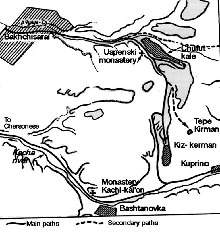
Side valley and cliffs.

{short description of image}

Caves in cliff side.

{short description of image}

Close up of caves.

{short description of image}

Uspenski monastery being reopened.

{short description of image}

Uspenski monastery buildings.

  {short description of image}

Illustration from an old book showing what the monastery in the ridge opposite Chufut- kale looked like in the 19th century.


{short description of image}

Cave area of monastery.

{short description of image}

Newer, outer wall from distance on approach road.

{short description of image}

Wall and gate in distance.

{short description of image}

Outer wall.

{short description of image}

Micha and Dr Belli talking fast to gain admitance.

{short description of image}

View along wall toward cliff and valley.

{short description of image}

John and Micha with Dr Belli on street.

{short description of image}

Group discussing the medieval town.

{short description of image}

George and Micha listening to Dr Belli's description.

{short description of image}

Home of Fiskovich.

{short description of image}

Home and town street.

{short description of image}

House on edge of cliff.

{short description of image}

House.

{short description of image}

Current Kariate home with horse.

{short description of image}

Kariate home.

{short description of image}

Kariate home and view off cliff.

{short description of image}

View from home along cliff, two kenessa buildings.

{short description of image}

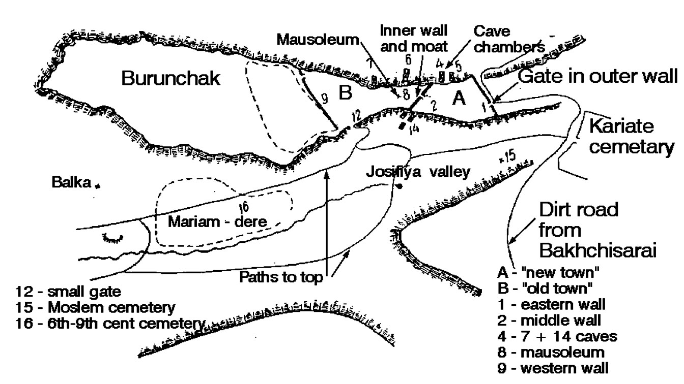
Inner, older wall and gate.


{short description of image}

Detail of the sign next to the inner gate noting that the wall dates from the 6th Century


{short description of image}

Inner wall and moat being cleaned.


{short description of image}

Dr Beli and Pavel preparing to go down into the moat and then further into the underground passage at the end of the moat. Here one can make out the hole in the wall ending the moat. It will appear in other photos as the entrance into the passageway. Not the steep cliffs across the valley.


{short description of image}

Sign on the moat in front of the inner wall


{short description of image}

Pavel and John examining defensive works. The original fortress wall is in the background. The moat was dug out of solid rock and also there were underground passages such as is behind the opening in the face of the moat here. Another series of works is just off the photo to the right, it appears in another photo. Note that the cliff is just beyond the end of the wall and the rock that ends the moat. See the far cliffs to get an idea of how steep these cliffs are.

{short description of image}

Micha in defensive cave room.

{short description of image}

View through cave window into valley.


{short description of image}

View from Chufut kale across adjacent valley.


{short description of image}

Mausoleum of Tokhtamish's daughter.

{short description of image}

Dr Belli describing history of two knessa's.

{short description of image}

Two knessa buildings.

{short description of image}

Close-up of smaller knessa.

{short description of image}

Kariate home beyond flower garden.

{short description of image}

Departing Chufu-kale via main gate.

To return to the Xenophon main page please click here.