|
Location: 44 degrees 37 min. N latitude - 33
degrees 33 min. E longitude, on the southwest corner of Crimea. The population
was 77,000 in 1914 and is over 500,000 today. We tour the city with visits to
the series of monuments to the city's heroic defense in the Crimean War of
1853-56 between Russia and the coalition of Turkey, Great Britain, France, and
Sardinia-Savoy.
Mr Sloan's first visit to the city was in 1992 when he organized a group
who were guests of the Commander of the Russian Black Sea Fleet to witness
Russian Naval Day (photos below) and again in summer 1993. This is a report
containing information about Sevastopol, with emphasis on its siege during the
Crimean War, that the authors obtained during a week long stay in the city in
July 1997. We wish to thank especially the staff of the Museum of the Heroic
Defense of Sevastopol and their families for their hospitality and extensive
support of our visit as well as for educating us on the history of the city.
This section is a small part of our overall effort to assemble information on
the history of the entire Crimea. For an outline please go to
Crimea For anyone wishing to visit Sevastopol
we highly recommend our outstanding travel agent Larissa Riazantseva at
UKRINTOUR in Kiev who can be reached by email at
uit@public.ua.net.
The Sevastopol is on a spectacularly beautiful natural harbor in Crimea formed
by the estuary of the Tcherniya River. In the 5th cent BC the area was already
a Greek colony called Chersonesus. See our discussion of
Chersonesus. From this and
nearby ports the Athenians fed their population with exported grain traded from
the Scythians. It then became part of the Roman empire and in the Byzantine
period was administrative headquarters for the region. It was captured by
Vladimir, prince of Kiev, but returned to Byzantium after his conversion to
Christianity. During the middle ages the
Feodoro Principality (capital at
Mangup-kale), allied with Byzantium built a small sea port and fortress at
Kalamita on a cliff at the
mouth of the Tcherniya River. After the Mongol conquest the Crimea was cut off
from the Russian cities. Chersonesus was destroyed during the war between
Tamerlane and Toktamish in 1399. The Tatars built a small town there, Ak Yar,
(Akhtiar) but had no need for a port.. After the Russian conquest of Crimea in
1783, the harbor was selected for the main base of the new Black Sea Fleet. It
was then named Sevastopol "the August city". The fortifications were
begun in 1826.
The first modern siege, lasting 11 months, occured during the Crimean War.
Several of the main battles of this war, Alma,
Inkerman, and
Balaklava are all discussed in detail
at the above web site (Crimea) .
The city was nearly destroyed and deserted until 1870 when it was refortified
and a new naval base started. The second siege, during World War II, was even
more devastating. The third siege, as a result of which the Soviet Army retook
the city, was not as lengthy. Since World War II the city has again become a
major naval base.
Now that it is no longer a 'closed' city, the region should see a great
expansion as an ideal tourist spot.
Map
Here is a schematic diagram showing the locations of the main bastions in
the Russian defense line. The British and French siege works occupied a
semicircle to the east and south of these fortifications.
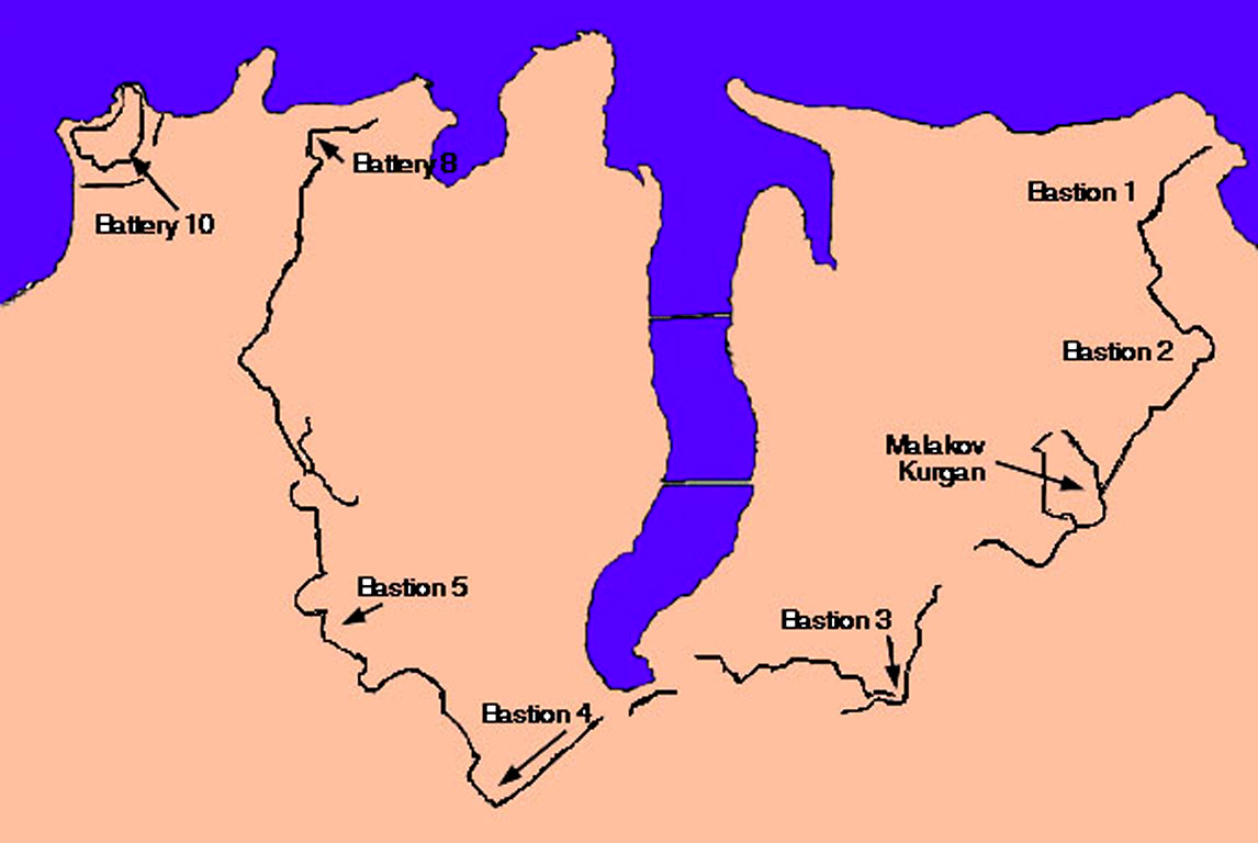
Many of the photographs shown below were taken at one or another of these
bastions, which are identified with the photographs. Not shown here is the
north side of the harbor, which was also fortified, but not attacked. For
additional maps of Sevastopol and Crimea and the Crimean War please see the
Crimea web page or the list of photos below. We also are privileged to have a
group of paintings from the famous book by Simpson. The Panorama Museum is located in
former Bastion 4. Our photos of the paanorama are not here, but at the
following site. Visit the museum.
The harbor consists of a main inlet some four-five miles long and 3/4 mile
wide, with several side inlets. The harbor is 65 ft deep. It was guarded at the
mouth by Forts Constantine to the north and Alexander on the south. Fort
Constantine was a three-tier, casmented position. Fort Alexander mounted 84
large cannon. To its west-south-west was Quarantine Fort. To the east was
Artillery Fort. These were the extreme right of the Russian defense line in
1854. The main harbor defense was at Fort Nicholas, a strong stone casmented
fort in three tiers on a promontory between the main harbor and Arsenal Creek.
Fort Paul was another three tier stone casemeted battery on the opposite
(northern) side of the entrance. Other harbor defenses were Fort Wasp, mounting
8 large guns on the cliff north of Fort Constantine, and Telegraph Battery,
with 28 guns between the two forts. During the siege a line of ships was sunk
across the harbor mouth and a large chain was stretched across, behind the
ships. During the Allied naval bombardment it was Fort Wasp and th eTelegraph
Battery that caused so much damage to the British ships.
A city tour should include the Defense Museum (currently the
Museum of the Black Sea Fleet see photos below) with a
review of the exposition "349 Days of Siege"; a visit to St. Vladimir
Cathedral on the Central Hill (1888); the burial place of prominent Black Sea
naval commanders M. Lazarev, V. Kornilov, P. Nakhimov, and V. Istomin; the
Cathedral of Saints Peter and Paul was rebuilt after the war; a visit to the
monument to the heroes of the incursions to the 3d Bastion, the monument to the
sunk ships, and the tower of the Kornilov Bastion on Malakhov mound; a tour to
the Memorial Panorama "Defense of Sevastopol" featuring a huge
picture depicting the storming of the Malakhov mound done in 1904 by a group of
painters headed by F. Rubo; a visit to the common grave cemetery on the
Northern side of the harbor with the Church of St. Nikolas that was erected to
commemorate the warriors who died during the defense of the city in 1854-55
(around 40,000 dead). Currently 427 common graves have been preserved. And
Gorchakov and Todleben are also buried here.
Now Sevastopol is a large city occupying both sides of the bay and
extending for several miles inland on the south side. The terrain is formed by
several long ridges that extend north and north-west, like narrow fingers from
the plateau of Sapun Gor. The valleys between these are almost ravines. The
northern end of these extend under water creating several narrow inlets off the
south side of the main harbor. In 1854 the town occupied only a very small part
of several fingers. The defense line could not encompass the entire area to
include the high ground to the south and east of the city. Consequently the
Russian engineers built a series of bastions along the three inner ridges and
connected them with entrenchments that also crossed the low ground between
them. But the defense line was nearly cut in two between Bastions 3 and 4 by
the long inlet known as South Bay. Thus the Allies were able to occupy
significant high ground quite close to the defender's positions. Here is a
British map from Kinglake's history of the war. And
more maps are here, and
here, and here. Note that the British call
Bastion 1=Battery of the point; Bastion 2=The Little Redan; Bastion 3=The
Redan; and Bastion 4=The Flagstaff Bastion.
Here we take a tour of the Russian positions to observe the view from Bastions
1, 2, Malakov, 3, and 4. Here is a set of more detailed diagrams showing the bastions.
Bastion 1 was located on the crest of the ridge overlooking the point where
Carenage inlet meets the main harbor from the south-west. Now it is near ul.
Khryleva. From this point one has uninterrupted views north and across the bay.
Note the white pyramid in the Russian cemetery. (For discussion see
cemetery.) View west to
the harbor entrance at the sea, with Fort Constantine at the point, and
north-east, east, and
east-southeast toward the ridge on which the
besiegers established their batteries.
From Bastion 1 the entrenchments ran along the ridge to Bastion 2., located at
the head of Carenage inlet and overlooking its extension up Carenage ravine.
Now there is a small park with a monument memorial to the units that served at
that location.
At Bastion 2 the defense line made a right angle to the right, crossing the
ridge and extending to the principal defense work, the Kornilov Tower and Bastion on Malakov Kurgan, which
held the entire ridge between the Carenage and South Inlets. (British maps name
this "Man of War Harbour"). General view.
This is the best preserved of the fortifications facing the land on the south
side of the bay. This location is being repaired as part of the museum complex.
Here are British cannon. The main fortification was
the Kornilov tower bastion, here from outside and
inside and the stairs
leading to second floor. Close up of one of the memorial plaques. We are standing on top. Still on top. Posing
for photos. And again.
The right side of the Kornilov bastion overlooks a ravine. View from the top
toward the south-east. View to the
south. The defense line is broken by the ravine and
continues on the other side to Bastion 3. (The Redan) An obelisk forms part of the monument at Bastion 3. View
of the monument at Bastion 3 View to
south-east. At Bastion 3 the line turns back to
right along the ridge toward the head of south bay (View to
south-east.) and then crosses the Vorontsov ravine
just at the head of South Bay. From there it climbs the steep hillside and
turns left along the ridge to Bastion 4. (The Flagstaff Bastion). This detailed
British map from Kinglake shows both The Redan and
Flagstaff Bastion plus the Peressip Batteries right at the water's edge at the
head of South Bay. Note the British siege parallels and batteries 7 and 8 on
the ridge overlooking the Vorontsov and Pickett House roads.
The Panorama Museum is now located in part of the Bastion #4 called
Flagstaff Bastion in British texts -a very large defensive work.The museum is
at Istouheski Bul'var. The military artist, Frantz Alekseevich Rubo (1856-1928)
was professor of military art at the St. Petersburg Academy. He became
interested in the battle at the Malakhov Kurgan on 6 June 1855 in which the
Russian garrison successfully held off the Anglo-French Army. In 1901 he
started work on a large painting. First he visited Sevastopol and studied the
historical documents to familiarize himself with the place. He discussed the
battle with participants and witnesses. Then he made a large cartoon for the
diorama in St. Petersburg. The painting was to measure 14 meters by 115 meters.
It was created in Munich, Germany with the help of the artists Shenkhen, Merti,
Frosh and twenty students of the Bavarian Academy of Art, who worked
simultaneous on the planned area of some 900 square meters. In the summer of
1904 the completed painting was taken to Sevastopol and, for the 50th
anniversary of the battle, 14 May 1905 it was opened to the public. The first
visitors were veterans of the Crimean War.
During the bombardment of Sevastopol in World War II on 25 June 1942 the
panorama was hit by a German bomb and set afire. The sailors and soldiers
fought the blaze for 2 hours and managed to save 86 sections of the original.
On the night of 27 June these were put on the last ship out of Sevastopol (the
Tashkent) along with wounded and women. The ship made it to Novorussisk. In all
about two thirds of the 1116 square meters was saved. After the war,
restoration was undertaken by a group of artists under direction of V. N.
Yakovlev (1893-1953) and P. P. Sokolov-Skalya (1899-1961). They used
photographs, documents, records, and original artist sketches to restore the
panorama. They tried to create a realistic portrayal of the battle and added
some new episodes. On the 100th anniversary, in October 1954, the panorama was
reopened to the public.
View from Panorama north to cemetary across
bay. View from another location in Bastion 4 toward north. View from Panorama to east. View to south-east.
View to south. Another view. At Bastion 4 the line makes a right angle and
proceeds more or less straight through Bastions 5 and 6 to the coast. These
last two locations are now thoroughly occupied by urban buildings making it
difficult to obtain views from them. Bastions 7 and 8 were overlooking the
outer harbor. This map gives a larger view of the
city on 25 September 1854. Note, what the British thought was 'Genoese fort' is
the ruin of Greek Chersonesus. The Wasp" was a small battery that created
havoc in the British ships during the single naval bombardment due to its
delivering plunging fire onto the decks.
Among the many monuments thoroughout the city are Nakhimov's statue on a pillar like Nelson's at Trafalgar
square, Admiral Kornilov's, General Todleben's,
Suvorov's bust, another Suvorov, and Prince Vladimir's. The museum of the
Black Sea Fleet also has important collections related to the Crimean War.
Museum of the Diorama of the Storming of Sapun Gora:
This is in a building on the heights east of town. The Soviet operation to
free the Crimea began on 8 April 1944. Soviet troops came from the north and
across the Kerch strait and peninsula. By 16 April they reached the German
defenses around Sevastopol. These were strongly echeloned and Hitler had given
orders not to surrender the city. The key position was at Sapun Gora Mtn. The
German defenses consisted of three and four lines of trenches with bunkers,
machine gun nests, barbed wired and mine fields.
The Soviet assault was supported by massive artillery and air bombardments.
On 7 May at 10:30 AM the ground attack began along the entire front. Especially
vicious battles took place in the area of Sapun, where the attackers fought for
each trench line. There were thousands of casualties. By 19:30 the Soviet
troops from the 77th and 32nd Guards Rifle Divisions reached Sapun Gor (hill).
Sevastopol was liberated by nightfall on 9 May and by 12 May the last German
resistance around Chersonesse was eliminated.
In 1956-57 the artist P. T. Mal'tsev, painted a cartoon for a picture
depicting the battle and received praise for it at an artistic meeting. Then he
and several other artists worked for seven months to create a painting from the
cartoon. The painting measures 5.5 meters by 25.5 meters and is 83 square
meters in plan. In August 1959 the battle painting left Moscow for Sevastopol
to be housed in a special building. The diorama was opened on 4 November 1959.
It shows an assault group from the 11th Guards Division and 63rd Rifle Corps.
It is semicircular whereas the Panorama of the siege in 1854 is fully circular.
|
|
|
Photo
number
|
Description
|
|
| |

|
Beskrovni map showing Sevastopol at the
beginning of the siege.
|
|
| |
|
Diagrams of Sevastopol fortification from
Beskrovni book
|
|
| |
|
Schematic of Sevastopol southern defense line
|
|
| |
|
Map from Beskrovni's Atlas of
Russian military history for attack on 8 Sept 1855.
|
|
| |
|
Map from Kinglake showing Captain Oldershaw's
fight on 13 April - details of Russian defenses at head of South Bay, Redan and
Flagstaff Bastion.
|
|
| |
|
Kinglake map of night battle of 22 March
showing main Russian defensive works.
|
|
| |
|
Kinglake map showing the city on 25 Sept.
1854 on eve of siege.
|
|
| |
|
Russian map from Beskrovni showing Russian
positions and allied siege works.
|
|
| |
|
Old map of Sevastopol
|
|
| |
|
Beskrovni map showing the storming of the
city.
|
|
| |
|
Map from Beskrovni atlas showing the battle
of Cherniya river on 16 Aug 1855. Photos from the Cherniya River battle area
are with the Balaklava battle web site.
|
|
|
|
View from Bastion #1 northwest across harbor
toward North Fort
|
|
|
|
View North, to right of pic 77 across harbor
|
|
|
|
View Northeast, to right of pic 78 across
harbor, white dot is pyramid in Russian cemetery.
|
|
|
|
View East-north-east, from Bastion #1 across
point of ridge on other side of Caranage bay toward Inkerman
|
|
|
|
View east to right of pic 75 across Caranage
bay to ridge occupied by Allies.
|
|
|
|
View from ridge behind Bastion #1 west over
harbor to sea with Ft Constantine at harbor entrance
|
|
|
|
Telephoto view of harbor and Ft Constantine
from area near Bastion #1.
|
|
| |
|
View across harbor from ridge by bastion 1 to
north
|
|
| |
|
View across harbor toward cemetery
|
|
|
|
Monument at Bastion #3
|
|
|
|
Close up of Monument - Bastion #3
|
|
|
|
View of Kornilov bastion on Malakov Kurgan
with cannon
|
|
| |
|
Outside Kornilov Bastion - Malakov Kurgan
museum
|
|
| |
|
Plaque - Butirsk Infantry regiment (oldest in
Russian army).
|
|
| |
|
Plaque - Borodino regiment
|
|
| |
|
Malakov museum British cannon
|
|
| |
|
George, John, Pasha examining a British
cannon
|
|
|
|
Memorial plaque at Malakov
|
|
|
|
Plaque - Defense tower Kornilov Bastion
|
|
|
|
Misha on top Kornilov Bastion
|
|
|
|
Group on top Kornilov Bastion
|
|
|
|
Pavel, Misha, John on top Kornilov
|
|
|
|
Group on Kornilov
|
|
| |
|
Inside Kornilov Bastion museum
|
|
| |
|
Stairs to upper level Kornilov Bastion
|
|
| |
|
Malakov Kurgan, Kornilov Bastion museum
complex
|
|
| |
|
View from top of Kornilov tower to SE
|
|
| |
|
View from top of Kornilov bastion to south
|
|
| |
|
View east of town to British positions
|
|
| |
|
View east
|
|
|
|
From Kornilov bastion on Malakov Kurgan
looking east
|
|
| |
|
View from Malakov over houses
|
|
| |
|
View from Bastion 3 to SE
|
|
| |
|
View from Bastion 3 toward south
|
|
| |
|
View from bastion 3 to SE
|
|
| |
|
View from bastion 3 to south
|
|
| |
|
View at head of South bay between hills with
bastions 3 (left) and 4 (right), defense line was near water edge
|
|
| |
|
View toward head of South Bay between Bastion
3 on left and 4 on right - British psns on ridge in center. Russian line
crossed right at end of bay
|
|
| |
|
South bay looking north toward main bay
|
|
| |
|
Mouth of South bay view north across main bay
|
|
|
|
View from bastion 4 (also called Flagstaff
bastion) across South bay
|
|
|
|
View to SE along inner harbor - south bay
|
|
| |
|
Panorama museum in distance
|
|
| |
|
Panorama Museum on ridge of Bastion 4, note
steep decline to harbor level
|
|
|
|
Panorama museum in distance on Bastion 4
|
|
|
|
View SE from Panorama museum
|
|
|
|
View south from Panorama
|
|
|
|
On parapet Bastion 4 at Panorama museum
|
|
| |
|
A close up of the reconstruction of the
rampart and embrasures with cannon at the bastion surrounding the museum.
|
|
| |
|
Reconstruction in concrete to show look of
gabions and sandbags
|
|
|
|
View from Bastion 4 across bay to north-
white pyramid in cemetery
|
|
|
|
View from Panorama museum north across
harbor to cemetery
|
|
|
|
View from Panorama southeast
|
|
|
|
View from Panorama to east
|
|
|
|
View from Panorama to south east
|
|
|
|
Bust of Admiral Istomin outside Panorama -
for more busts to to the Panorama section.
|
|
| |
|
Ferris wheel at Panorama museum
|
|
|
|
View from Inkerman area toward city
|
|
|
|
View of city from east.
|
|
|
|
View from Inkerman toward city
|
|
|
|
View toward Inkerman from Cathcart hill
|
|
| |
|
View from Cathcart hill area north along
British lines toward Inkerman
|
|
|
|
Memorial, British cemetery
|
|
|
|
British memorial
|
|
|
|
Sevastopol city street
|
|
|
|
Cathedral downtown Sevastopol
|
|
|
|
Building on downtown street corner
|
|
|
|
View ditch in North Fort
|
|
|
|
Pyramid in Russian cemetery
|
|
|
|
Pyramid, another view, near sunset
|
|
|
|
B/W of painting of naval battle at harbor
|
|
| |
|
Illustration of defensive fortification -
from 19th century book
|
|
| |
|
Illustration showing the harbor with line of
sunken ships - from 19th century book.
|
|
| |
|
Illustration of Sevastopol harbor with
fortifications clear on both shores.
|
|
| |
|
Illustration from 19th century showing
remains of town with a church that is still standing.
|
|
|
|
Display of recovered British regimental hat
insignia, for sale
|
|
|
|
Museum of Black Sea Fleet, weapons outside
|
|
|
|
Museum of Black Sea Fleet, building
|
|
|
|
Museum of Black Sea Fleet
|
|
| |
|
A painting showing part of the Panorama. It
is on the wall in the Museum of the Black Sea Fleet
|
|
| |
|
Bust of Admiral Kornilov in the Museum of the
Black Sea Fleet
|
|
| |
|
Bust of Admiral Nakhimov in the Museum of the
Black Sea Fleet
|
|
|
|
Fort Constantine at harbor mouth from
Chersonesus Penn, view north
|
|
|
|
View from Chersonesus across Quarantine bay
inlet to city
|
|
|
|
Fort Constantine from middle of harbor
|
|
|
|
Statue of Grand Prince Vladimir
|
|
|
|
Bust of Suvorov
|
|
| |
|
Bust of Suvorov
|
|
|
|
Statue of Todleben
|
|
| |
|
Monument to Admiral V. A. Kornilov
|
|
|
|
Statue of Admiral Nakhimov
|
|
|
|
Sunset over harbor view from north side
toward WSW
|
|
|
|
Sunset view south across harbor
|
|
|
|
View of Artillery bay toward sunset
|
|
|
|
View of Artillery bay in the morning
|
|
|
|
Bay south-west of Chersonese
|
|
| |
|
World War II armored railroad train engine on
siding in Sevastopol
|
|
| |
|
Large caliber railroad artillery piece
|
|
| |
|
Close up of railroad artillery piece
|
|
| |
|
Side view of railroad artillery
|
|
| |
|
Another view of railroad artillery
|
|
| |
|
Memorial at Sapun Gor
|
|
| |
|
Close up of monument at Sapun Gor
|
|
| |
|
Detail of the diorama in the museum at Sapun
Gor. It depicts the Russian troops storming the Sapun ridge line to drive out
the Germans who had previously captured Sevastopol.
|
|
| |
|
Outdoor exhibit at Sapun Gor museum
|
|
| |
|
Naval guns at Sapun Gor museum to WWII
|
|
| |
|
Naval guns at Sapun Gor
|
|
| |
|
Tanks at Sapun Gor museum
|
|
| |
|
Tanks at Sapun Gor museum
|
|
| |
|
Typical newer suburban highrise apartments
|
|
| |
|
Typical newer suburban highrise apartments.
|
|
| |
|
New construction in suburb SE of city
|
|
|
|
Goats close to Sevastopol in suburbs
|
|
|
|
New construction in suburbs taking over
allied siege lines.
|
|
| |
|
New home - "Mafia" type for newly
rich
|
|
| |
|
New walled home with some Tatar architectural
influence
|
|
| |
|
Russian Navy Day demonstration - sailors of
Black Sea Fleet forming letters "Glory to Black Sea Fleet"
|
|
| |
|
Black Sea Fleet sailors having a boat race
|
|
| |
|
Carrier Moskva with submarine in foreground
|
|
| |
|
Russian landing ship open with amphibious
BMP's conducting firing exercise
|
|
| |
|
Navy Day festival - Neptune's court arrives
at reviewing stand
|
|
| |
|
Navy Day "hovercraft" vessel
|
|